Mapping underground rivers at the Copeton Diamond Field, New South Wales, Australia. Following these “deep leads” to further riches

By Robert R. Coenraads

Keywords: Alluvial diamond, basalt, Bingara, Copeton, deep lead, Delungra volcano, Gwydir River, New England Gemfields, palaeochannel, palaeodrainage, palaeotopography.

Background

In Australia’s ‘New England’, early gold and tin explorers discovered diamonds in their sluice boxes without realising their significance, but by the 1890s the Copeton-Bingara area had grown into New South Wales’ premier diamond area with a total reported production of 202,000 carats, although actual production probably far exceeded this amount (MacNevin, 1977). Most of the diamonds were mined via shafts and drives between 1873 and 1922, with minor production continuing until 1960. Today the diamond field lays abandoned.

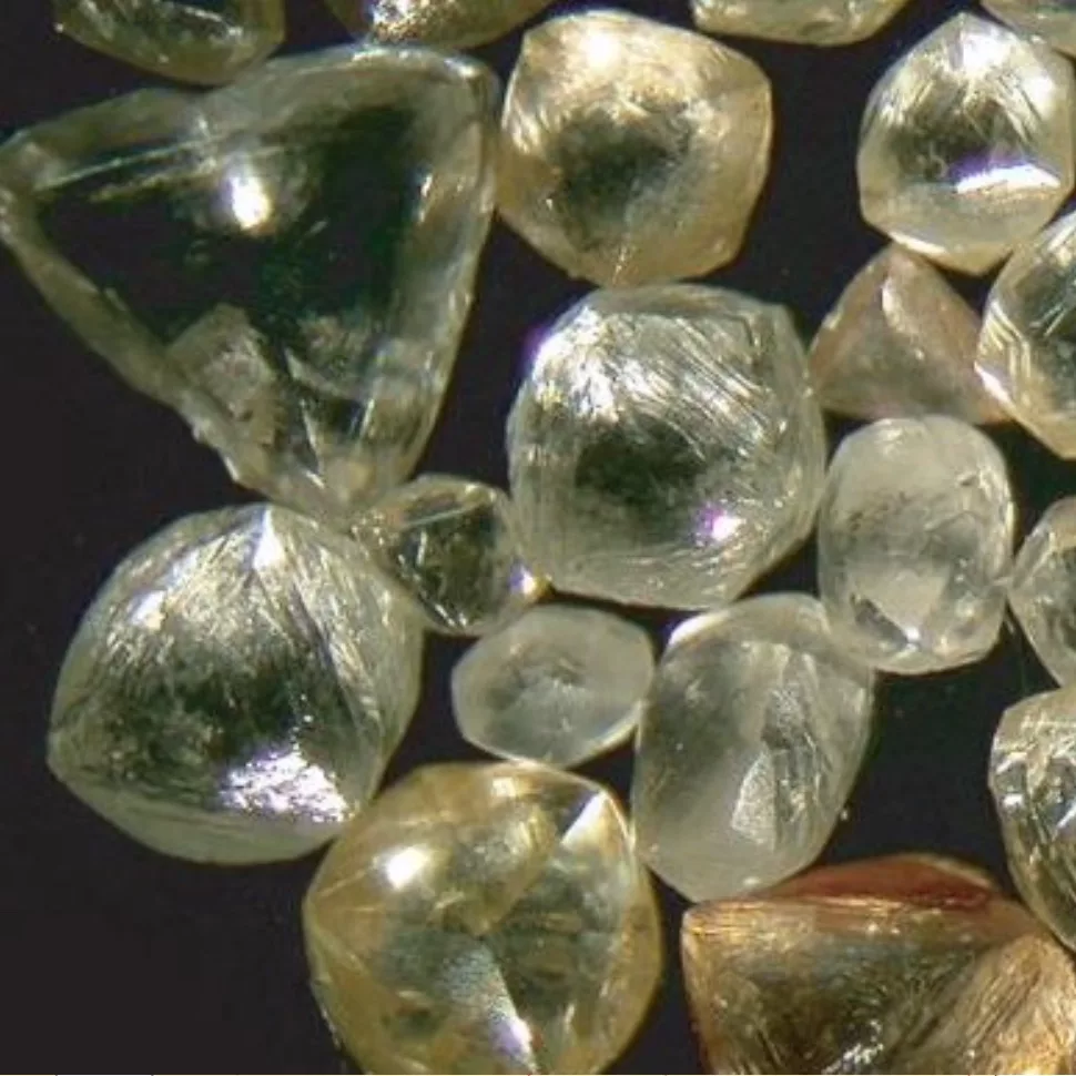
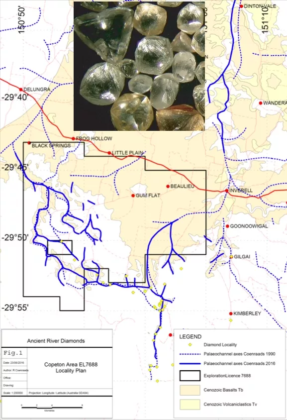
The glossy, rounded Copeton diamond crystals (Figure 1 inset) were known in Antwerp’s diamond cutting circles as ‘can-ni-faire’ or ‘impossible to cut’ (Curran, 1897; Idriess, 1948).

Their resorbed crystal forms are discussed by Hollis (2003) and their enigmatic origins remained a mystery for many decades. Barron et al. (1996) proposed that they formed when cold slabs of oceanic crust and their overlying carbon-rich sediments were subducted beneath the Australian continent and pushed down into the correct depth/pressure range for diamond crystal growth.

MacNevin (1977) reports the presence of fragile polycrystalline boart up to 12 carats in size from the Copeton Field suggesting local sources for the diamonds because such material cannot withstand transport in a river.

The Copeton deep lead alluvial deposits have long been recognised as river channel deposits that were buried by basalt lava flows with the richest grades of diamonds and other heavy minerals found along the channel axes. Idriess (1948) in his book, ‘Stone of Destiny’ poetically describes how the diamond-bearing deep leads in the Copeton area formed following eruption of the Delungra Volcano:

“Millions of years ago this lost river had come roaring from the mountain tops to sing its song of freedom under sunlight, down to the distant plains, flowing on placidly to the far away ocean. Then a black day came when the volcanoes erupted in a sea of fiery lava, which for all time drowned the river. What a sight for the gods! The river in unbridled triumph, plunging along its mountain course in foamy cascades of all powerful water; then the mountain tops catching fire, belching lava in molten fury down into the river; steam clouds hissing skyward against the volcanoes’ fiery smoke. A titanic battle, that between fire and water, a terrifying holocaust as the tortured river was slowly overwhelmed. And in its silenced bed now lay the diamonds.”

In the quest for these diamonds many attempts were made to map the course of the buried Copeton palaeochannels (Anderson, 1888; Stonier, 1895; Curran 1897; Pittman 1897; Cotton 1914; Gibbons and Pogson, 1963; Fried 1988; Smith 1988; Coenraads, 1990). The palaeotopographic analysis carried out by Coenraads (1990) covered most of the New England at 1:25,000 scale producing a more widespread and detailed study than previously possible.

The Coenraads (1990) maps were updated over the Copeton Diamond Field as part of the Ancient River Diamonds Pty Ltd work programme for Exploration Licence EL 7688 (Coenraads, 2015). The reinterpretation used the Fugro airborne geophysical maps (Brown 2006). The magnetic data, radiometric data and total count data show a remarkable contrast between the basalt lava flows and underlying basement rocks allowing extremely accurate mapping of their geological contact.

Figure 1: Diamond-bearing deep-leads associated with the palaeo-Gwydir River buried beneath basalts of the Delungra Volcanic Suite in the vicinity of Copeton Dam west of Inverell, NSW. Inset photo shows typical resorbed Copeton ‘can-ni-faire’ diamond crystals.

The Gwydir River appears to have been progressively diverted from its original northerly course, through a series of at least four westerly-stepping increments to its present course. The drivers for this diversion are the 19-24Ma volcanic activity centred on Mt Russell, near Little Plain, to the northwest of Inverell. The resultant “treasure map” presented here (Figure 1) connects the known and historically mined-out deposits to as-yet-undiscovered targets hidden beneath the basalt flows that filled these ancient palaeochannels.

Conclusions

The Gwydir River in the Copeton-Bingara area was forced to change course at least four times in the last 20 million years due to uplift and faulting associated with the growing Delungra Volcano. Originally flowing north, the Gwydir was turned gradually westwards and, with each diversion, its payload of alluvial diamonds was carried off into a different area. The older diamond-bearing channels were progressively filled and ‘fossilized’ into ‘deep leads’ by the volcano’s advancing basalt lava flows. Over the intervening years to the present day, erosion and down-cutting by modern streams has inverted the landscape by wearing down the surrounding hills and leaving proud the ancient diamond-bearing channels as isolated caps or shoestring ridges of hard basalt. Today, portions of the palaeo-Gwydir River and its diamond-bearing gravels lie, as-yet, undiscovered beneath their protective basalt capping to the north and west of Copeton. Furthermore, potential still remains for the discovery of primary diamond sources, possibly dykes, within the catchment of the Gwydir palaeodrainage system as indicated by north-south trending linear features visible in the Fugro airborne magnetic data (Brown 2006). Exploration licence EL8640 (formerly EL7688 in Figure 1) is currently held by Copeton Diamond Mines Pty Ltd with an aim to mine the basalt-covered channels and explore for potential diamond sources.

References:

  • Anderson, W. 1888. Appendix No. 8 in Report in progress for 1887 by the Geological Surveyor in Charge. Report, Department of Mines NSW for 1887 155-156.
  • Barron, L.M., Lishmund SR, Oakes GM, Barron BJ and Sutherland FL 1996. Subduction model for the origin of some diamonds in the Phanerozoic of eastern New South Wales. Australian Journal of Earth Sciences 43, 257-267.
  • Brown, R.E., 2006. Inverell Exploration NSW geophysics — new data for exploration and geological investigations in the northern New England area of New South Wales, Quarterly Notes July 2006 No 121, Geological Survey of New South Wales, NSW Department of Primary Industries.
  • Coenraads, R.R., 2015. Final annual report for EL7688 for the period ended 19/01/2015. Ancient River Diamond Project, Unpub report Ancient River Diamonds Pty Ltd, 6th February 2015.
  • Coenraads, R.R., 1990. Key Areas for Alluvial Diamond and Sapphire Exploration in the New England Gem Fields, New South Wales, Australia. Economic Geology 85, 1186-1207.
  • Cotton, L.A., 1914. The diamond deposits of Copeton, New South Wales, Proceeding of the Linnean Society of New South Wales 39, 803-838.
  • Curran, J.M., 1897. On the occurrence of precious stones in New South Wales and the deposits in which they are formed. Journal of the Proceedings of the Royal Society of New South Wales, 30, 228-237.
  • Fried, A.W., 1988. Equilibrium landscapes and drainage evolution in the Glen Innes/Inverell region. Unpublished Honours Thesis, University of Sydney, 64pp.
  • Hollis, J.D., 2003. Morphology of diamond crystals from the Bingara Range, Northern New South Wales, Australia: Volume 21, Number 9, January-March 2003, 350-359.
  • Gibbons, G.S., and Pogson, D.J., 1963. Diamond Deposits at Mt Ross. Unpublished report, Geological Survey of New South Wales GS1963/002.
  • Idriess, I.L., 1948. Stone of Destiny. Angus & Robertson, Sydney & London 344pp.
  • MacNevin, A.A., 1977. Diamonds in New South Wales. Geological Survey of New South Wales, Mineral Resources 42, 125pp.
  • Pittman, E.F., 1897. Report on the Boggy Camo diamond fields. Annual Report Department of Mines NSW for 1896, 98-99.
  • Smith, N.M., 1988. Reconstruction of the Tertiary drainage systems in the Inverell Region. Unpublished Honours Thesis, University of Sydney.
  • Stonier, G.A., 1895. Report on the Bingara diamond fields. Ann. Report Dept of Mines NSW for 1894, 131-136.